Summary
%%{init: {'theme': 'base', 'themeVariables': { 'primaryColor': '#FFC94A' , 'lineColor':'#327CA7'}}}%%
flowchart LR;
id1[Remote Sensing]-->id11[Sensors];
id11-->id111[Types of Sensors];
id111-->id1111[UAVs and Drones];
id111-->id1112[Airplane and Helicopters];
id111-->id1113[Low Earth Orbit Satellites];
id11-->id112[Types of Resolutions];
id112-->id1121[Spatial Resolution];
id112-->id1122[Spectral Resolution];
id112-->id1123[Temporal Resolution];
id112-->id1124[Radiometric]
id11-->id115[Types of Orbits];
id115-->id1151[Geostationary];
id115-->id1152[Sun-synchronous];
id115-->id1153[Polar];
id1-->id12[Types of Remote Sensing];
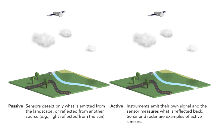
id12-->id121[Active Sensor];
id12-->id122[Passive Sensor];
id1-->id13[Electromagnetic Spectrum];
id13-->id131[Spectral Bands];
id131-->id1311[Multispectral];
id131-->id1312[Hyperspectral];
id1-->id14[Image Classification];
id14-->id141[Supervised Classification];
id14-->id142[Unsupervised Classification];
id14-->id143[Object-based Image Analysis];
id1-->id15[Applications and Uses];
id15-->id151[Agriculture];
id15-->id152[Climate Change];
id15-->id153[Disasters];
id15-->id154[Environment];
id15-->id155[Urban];

Remote sensing data is digital images and digital images are made of pixels, and pixels are representations of numeric values.
Those values represent the amount of reflected electromagnetic energy (which is everywhere, and everything reflects or absorbs it differently, and measurably). The sunlight is hitting the earth and the earth reflects the light and satellites capture it.

| Advantages |
- Very high resolution imagery
- Programmable flight paths
- LIDAR capabilities |
- High resolution imagery
- Pilot-flown flight paths
- LIDAR capabilities |
- High to coarse resolution imagery
- Large coverage extent |
| Disadvantages |
- Very small coverage extent
- Visual line of sight |
- Small coverage extent
- Flight operation |
- Coverage limited to orbital path
- Cloud obstructions |


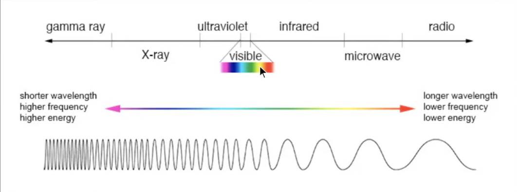
Electromagnetic energy has waves, have wavelength. According to Maples (2021), below is the illustration of electromagnetic waves.
Source: Google Earth Engine 101 Stanford Geospatial Centre
Spectral sampling
RGB, Red Green Blue Spectrum
reflect vs absorb
in each spectral/spectrum, the image will be white if it reflects the spactrum
255 spectrum of each RGB
Observing the surface of the earth
Satellites can see OUTSIDE RGB (more than 3 spectrum/band), such as infrared, panchromatic (black n white, take the intensity value), shortwave infrared, thermal infrared, etc (Maples 2021).
Classifying the pixels through the wavelength
Applications
Examples of applications of remote sensing in these sectors:
Agriculture: Mapping crop types in the US Midwest Chapter A1.1
Climate change: Air pollution and Population Exposure Chapter A1.4 using gridded air pollution data from Sentinel-5P.
Disasters: Active fire monitoring Chapter A3.1
Environment: Mangroves change mapping Chapter A3.3 using map-to-map change detection between 2000 and 2020.
Urban: Impact of urban expansion (urban classification) Chapter A1.2
Personal Reflection
I first learned about remote sensing during my undergraduate studies about ten years ago, and I’m amazed at how much it has changed. This module is a refresher and updated version of knowledge and technologies that I previously learned.
My mind is blown by how far the resolutions have advanced. I used to work on a 16-day temporal resolution, 7+1 bands, and 15–60 m spatial resolution on Landsat 7’ image. At my job in the mining industry, I mostly used satellite images to create topographic maps and calculate the volume of coal extraction and overburden removal using a DEM (Digital Elevation Model).
With the most recent technology, the improvement of remote sensing satellites such as Sentinel with higher resolutions and Google Earth Engine allows us to do different and more extensive analyses such as object-based image detection with better and faster results.
Maples, Stace. 2021.
“Google Earth Engine 101.” ArcGIS StoryMaps. May 13, 2021.
https://storymaps.arcgis.com/stories/cdfc91d050634a5294ac897acc959d55.